Unroll a good map of the Roman Empire and you’ll see the Mediterranean like a blue hearth, ringed by provinces with names that hum like old iron: Britannia, Gallia, Hispania, Africa, Achaea, Syria. Look closer and the sea gives way to lines—straight as thrown javelins—crossing mountains and marsh and empty steppe. Those lines are roads, and together they read like stitching: a careful, relentless threadwork that made a quilt of conquered lands and called it Rome.
These roads were more than a way to get somewhere. They were policy in stone, logistics made visible, sovereignty you could feel underfoot. Where Rome ruled, roads appeared—and with roads came legions, tax men, couriers, merchants, pilgrims, and gossip. Latin hurried along their surfaces and settled in markets and barracks; law followed, then customs, then architecture, then habit. In time, those threads didn’t just hold the quilt together. They became the fabric.
This is the story of how Roman roads—some 250,000 miles of them, about 50,000 miles paved—kept the empire breathing in one rhythm from Britannia to Syria.
Roads as Presence and Promise
Every empire projects power; Rome paved it. A Roman road did two things at once:
- Declared presence. In newly conquered territory, a road was a proclamation: Rome is here to stay. Stone doesn’t apologize.
- Enabled movement. Troops, officials, traders, and travelers could now count on speed and predictability—the twin gods of imperial administration.
From the first paving stones of the Appian Way (312 BCE) to the last milestones hammered into provincial verges, roads turned distance into manageable time. And in an age with no stirrups and few gentle saddles, a prepared surface mattered. A legion could march twenty to thirty miles a day; news and orders moved even faster.
The Roman Way of Making Roads
If a road is a promise, its construction is the oath. The Romans swore it with method.
Step 1: Choosing the Line—“As Straight as the Gods Permit”
Roman surveyors—gromatici—took their name from the groma, a cross-armed sighting tool for laying out straight lines and right angles. They used the chorobates (a long, spirit-level-like bench) for leveling, and at scale, they relied on stakes, flags, and sightlines to drive a route as straight as terrain allowed. Hills and rivers counted as obstacles, not excuses. Straight roads mean shortest distances and easier wayfinding—vital when moving an army, a tax convoy, or a courier with war news.
Step 2: Cutting the Trench—Foundation First
Crews dug a trench along the marked line. The depth depended on soil and climate, but the goal never varied: create a stable base that resists frost heave, mud, and time.
Step 3: Layering the Road—Four Courses to Forever
While methods varied by region, the classic Roman cross-section stacked multiple layers:
- Statumen: a bottom course of large, flat stones set as a load-spreading raft.
- Rudus: a thick layer of rubble or broken stones, compacted with lime mortar for rigidity.
- Nucleus: finer gravel or sand, sometimes lime-bound, compressed into a tight mattress for the surface.
- Pavimentum (or summum dorsum): the surface course—tightly fitted polygonal stones or flat paving slabs, often crowned (subtly arched) to shed water.
Roads were flanked by ditches for drainage and sometimes raised (an agger) for dryness and visibility. In towns, curbstones and stepped sidewalks sheltered pedestrians; in the countryside, milestones (milliaria) gave distances and often named the emperor who funded or restored the section.
Step 4: Details That Last—Drainage, Camber, Craft
What looks simple from above is cunning up close. The camber (gentle tilt from center to edge) sent rainwater into ditches. In wet zones, culverts and stone-lined drains kept the subgrade dry. In earthquake country, flexible layers absorbed shock. The result? Segments still walkable two millennia later.
Bridges, Gates, and Waystations
A road is only as fast as its slowest crossing. Roman engineers turned rivers from hazards into assets with stone arches and timber-truss bridges, then guarded key points with gates, watchtowers, and fortlets. Along major routes, waystations—mansiones for overnight rest and mutationes for changing horses—created a relay rhythm that kept traffic moving. On the city edge, triumphal gates did double duty: decoration for conquerors, checkpoints for customs and control.
The Appian Way
When the Via Appia opened in 312 BCE, running from Rome toward Casilinum (Capua) and later to Brundisium, it wasn’t just a road; it was a manifesto. Permanent paving meant Rome’s armies could march with confidence, merchants could plan routes, and the state could enforce regularity. Rome was writing policy into the ground.
Speed, Security, Control
The Romans understood a blunt truth: speed is a weapon. A straight, hard road lets a commander move a legion to a hotspot before a revolt becomes a war. Patrols along roads deter banditry. And a road tells would-be rebels something critical: the empire is never far away.
The Cursus Publicus, the imperial courier system, depended on roads like a bloodstream depends on arteries. State-owned horses, organized relay stations, and official warrants turned what might have been months of travel into days. Intelligence, orders, tax assessments, and diplomatic packets flowed—and with them, coherence.
Markets, Prices, Taxes
An empire lives on its economy as much as on its swords. Roman roads knitted coasts to interiors, linking ports to inland markets and river routes to coastal towns. The effect was a market web:
- Egyptian grain (mostly by sea) fed Rome and Italy.
- Spanish olive oil and gold moved east.
- Provincial specialties—glass from Syria, wool from Britain, wine from Gaul—found buyers empire-wide.
Standardized distance markers and predictable travel times stabilized prices and schedules. Procurement officers knew when a shipment should arrive; missed dates could be investigated along a known route.
And taxes? No empire survives without them. Procurators used roads to assess and collect land and poll taxes. On the verges and at gates, the state levied the portoria—customs dues based on a cargo’s value. Good roads meant more predictable revenue, fewer “lost” convoys, and policy that could actually reach the provinces.
Inns, Markets, and News
A road is a conversation stretched over miles. With ease of travel, market towns sprouted where routes crossed rivers or other roads. These places—part rest stop, part bazaar—became nodes where local merchants met imperial traders, where soldiers swapped news with pilgrims, where ideas rode the same wheels as amphorae. The exchange wasn’t just commercial; it was cultural. The latest customs, rumors, and religions moved from one hearth to another, invisibly gluing regions to a shared sense of what was Roman.
In Britain, the settlement the Romans called Lagentium (modern Castleford) grew around a legionary fort. Straddling routes across northern England, it became a waystation that pulsed with traffic and trade—a small proof that roads make places, not just paths.
Roads as Symbols
Even when no one walked them, Roman roads signified. To locals in freshly subdued territory, a straight, stone-laid highway looked like permanence. Milestones naming the reigning emperor made it personal. Public inscriptions credited governors and legates who repaired sections, turning maintenance into public relations. In short: a road was a line of propaganda you could follow to the horizon.
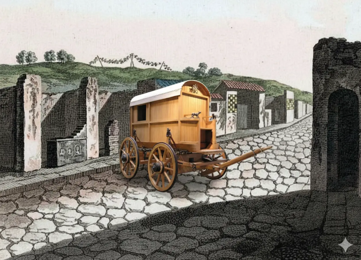
Pompeii’s Streets
In cities like Pompeii, you can still see the road’s life in microcosm: raised sidewalks to keep feet dry, stepping stones to cross during rains, wheel ruts cut into stone by decades of carts, and water towers feeding public fountains. It wasn’t just long-distance highways that carried Rome; it was the last mile, too, where engineering met daily routine.
How Fast Was Rome, Really?
By modern standards, the empire moved slowly. By ancient standards, it was a miracle of timeliness. A seasoned legion covering 20–30 miles a day could reach a frontier in a week; a Cursus Publicus dispatch galloped from provincial capital to Rome in a fraction of the time an unpaved landscape would permit. Merchants could predict delivery windows; governors could draft itineraries; families separated by wars could trace a route to reunion.
Predictability is a kind of freedom. So is security. Roman roads gave people both, and they used them.
Cultural Highways
The empire’s most durable conquest wasn’t a province; it was a mindset. Roads carried culture. As legions secured regions and engineers fanned out with stakes and levels, the following caravan rarely lagged far behind: Latin, Roman law, building styles (baths, amphitheaters, forums), and religions old and new. Local identities didn’t vanish; they hybridized—think Gallo-Roman in Gaul, Romano-British in Britain.
Over centuries, Latin became the lingua franca—not because Rome forced it at swordpoint, but because roads rewarded those who used the language of contracts and commands. Long after the emperors fell, those vowels became the Romance languages—Spanish, French, Italian, Portuguese, Romanian—spoken across lands once connected by Roman arteries.
Stand at a milestone and imagine what it told a farmer, a veteran, a new magistrate. It whispered confidence: the next town is X miles; there’s a bridge at the river; if something goes wrong, the legion can come. A paved surface isn’t just easier on hooves; it’s easier on nerves. The sense that the world works—that distances are knowable, that journeys can be planned—seeps into people. Cities flourish; arts develop; even religion moves from place to place with fewer frictions. The road becomes part of the mental map of what is possible.
Who Built, Who Guarded, Who Paid
Roads cost time, labor, and treasure. Rome’s genius was to spread those burdens across the apparatus of empire:
- Legions and auxiliaries built new stretches—especially in frontier zones—then guarded them.
- Provincial communities took on maintenance by edict or in exchange for privileges.
- Contractors provided materials and labor; officials recorded costs and credited donors on inscriptions.
- Toll points and customs posts recouped outlays through the portoria.
It wasn’t cheap. It was cheaper than losing a revolt because your army got bogged in a marsh.
Wear, Repair, and the Long View
Stone lasts; empires don’t. Yet many Roman roads outlived their builders by centuries because Romans built for repairability. Surface stones could be lifted and relaid; drains could be cleared; bridges resurfaced. Milestones doubled as maintenance logs, recording who restored what, when. Administratively, a road was a ledger as much as a line—proof that Rome kept promises even after the ribbon-cutting.
“All Roads Lead to Rome”
The proverb isn’t just poetry. The itineraries of antiquity—the travel lists and route maps—show an empire organized around Rome as a hub. Not every road pointed to the capital, but enough did, and the ones that mattered linked provincial capitals to Rome through clearly marked stages. For those who lived under the eagle, the center of the world wasn’t a philosophical ideal. It was a destination with a mile count.
Case Study Snapshots
Via Egnatia: The Balkans’ backbone, joining the Adriatic to Byzantium and on to Asia, stitched western and eastern theaters—military and commercial—into a single strategy.
Pompeii’s lanes: Everyday engineering that made cities walkable and washable.
Lagentium (Castleford): A fort-turned-crossroads town in northern Britain, proof that roads plant settlements the way rivers plant floodplains.
The Appian Way: A 300-mile signature that taught the Mediterranean to expect stone underfoot.
In the end, Roman roads tell us what power looks like when it learns to listen to physics: grade, drainage, load, time. They also tell us what people do when given predictable infrastructure: they move, trade, marry, argue, pray, sing, write, and change. The Romans did not invent roads, but they perfected the idea that a road is a statecraft machine—one that turns chaos into schedule, distance into duty, and strangers into neighbors.
Key Takeaways
- Rome built roughly 250,000 miles of roads, about 50,000 paved—a system that converted geography into governable time.
- Engineering discipline—surveying, layered construction, drainage, camber—made roads durable and repairable.
- Roads enabled military speed, courier efficiency (Cursus Publicus), and fiscal reach (tax assessment and portoria tolls).
- They powered the economy, linking ports to interiors and stabilizing prices and schedules across regions.
- Their greatest triumph was cultural diffusion: Latin, law, architecture, and habit traveled the same lanes as grain and oil.
- The proverb “All roads lead to Rome” reflects a real administrative design: a hub-and-spoke imperial mindset etched in stone.
FAQ
Were Roman roads perfectly straight?
As straight as terrain allowed. Surveyors prized straight alignments for speed and maintenance, but deviated for rivers, ravines, and mountains.
How fast could messages travel?
With the Cursus Publicus relays, official dispatches covered in days what ordinary travelers needed weeks to cross—thanks to fresh horses and scheduled waystations.
Did only the army build roads?
Legions and auxiliaries did much frontier work, but provinces, municipalities, and contractors handled significant stretches, especially maintenance.
Why do so many Roman roads survive?
Deep foundations, smart drainage, and the ability to lift and relay surfaces. Many later European roads simply adopted Roman alignments.